Technology Transfer during the construction of Lake Biwa Canal
Naoto TANAKA
I examine the transition of urban development along the Lake Biwa Canal that was based on the function of navigation systems, and consider the effect of infrastructure on urban development. The Lake Biwa Canal was constructed in the 19th century by using water from the Lake Biwa, applying the latest technology of the Meiji period. This canal has produced many amenities in the 100 years since its construction, in spite of the disappearance of shipping there. It was found that providing a navigation system was one of the most important functions of the Lake Biwa Canal, and technology of its construction were reflective of Japanese climate and culture at that time.
Key Words : Lake Biwa Canal, Navigation Systems, Urban Development, Design and Planning of Infrastructure, Environmental Design
|
1. Introduction
It is useful for infrastructure planning to learn past technologies of civil engineering and study the process of urban development. We classify the transition of urban development along the Lake Biwa Canal (called the LBC, below) that was based on the function of navigation systems, and consider the action of the infrastructure on urban development.
The Lake Biwa Canal was constructed in the 19th century using the available technology of the Meiji period. It utilized water from the Lake Biwa, and provided many amenities in the 100 years since its construction.
In this paper, I deal with the history of water supply planning from Lake Biwa to Kyoto, centering on the plan of the LBC. The data to be discussed below were collected from historical books, drawings, photos, and maps1)2)3)4)5)6)7)8). Based on these data and design surveys, two issues are focused on: 1) the period before the construction of the LBC (section 2), and 2) the actual plan of the LBC (section 3).
2. Before the construction of the Lake Biwa Canal
This section describes the historical materials regarding the plans to divert water from Lake Biwa to Kyoto prior to the actual plan of the LBC. The technical problems involved in each plan are also described.
The oldest plan which having related things, was made in 1614 by Yoichi SUMINOKURA whose father, Ryoi had managed navigation systems of the Takase River. Table.1 shows 12 plans for supplying water from Lake Biwa to Kyoto. Ten plans had maps drawing the route of canal. Analysis of these plans resulted in terns of the four characteristic routes shown in Fig.1.
Table 1 Plans of water supply from Lake Biwa to Kyoto before the LBC.
| No. | year | outline of plan | route |
| 1 | 1614 (Keicho 19) | Yoichi SUMINOKURA suggested the plan using Seta and Uji Rivers to the Tokugawa Shogunate. | A |
| 2 | 1800 (Kansei 12) | Korenao YANO, a painter of pictorial maps, made the plan. | B |
| 3 | 1841 (Tenpo 12) | Hikosuke, a farmer living in Saiou-ji Mibu Kyoto, requested a water supply plan to thte court of Kyoto. | C�D |
| 4 | 1862 (Bunkyu 2) | Hisaaki NAKAGAWA, the load of Oka Clan, Bungo Kyushu, requested water supply plan to the Imperial Court. (on Norvember 28th) | - |
| 5 | 1863 (Bunkyu 3) | 7 noted persons in Otsu-cho Oumi requesed water supply plan. (only plan) | D |
| 6 | about 1867 | Hyakusou-Kabu-nakama, the guild of shipping in Otsu, mad the plan. | D |
| 7 | 1872 (Meiji 5) | Gennosuke YOSHIMOTO and Shigezaemon KIKUNOI and others made an application of "the plan of development new canal for shipping" to Kyoto prefecture. (on May 27th) | D |
| 8 | 1873 (Meiji 6) | Isuke WATANABE and 6 persons, who belonged to Otsu first company trading rice, made an application of new canal by way of Yamashina and Roku-jizo to the Shiga prefecture. | C |
| 9 | about 1873 | A plan for navigation system was made by Fan Doora, an engineer from the Netherlands. | C/D |
| 10 | 1874 (Meiji 7) | Yojibei YOSHIZUMI and 4 persons, who belonged to teh steamship company on Lake Biwa, made an application "the development a new canal from Lake Biwa to Saikyo (Kyoto)" to Shiga prefecture. (on August 18th) | - |
| 11 | 1876 (Meiji 9) | Yojuro NAKAMURA and Chujiro UNO made an application to "the survey of new canal"to Shiga prefecture. (on January 13th) | D |
| 12 | 1884 (Meiji 17) | Yogyo TANI, a doctor lived in Kyoto, made a plan to "water supply from Lake Biwa to Shirakawa-mura village" to Kyoto prefecture. (on February 20th) | B |

Fig.1 Four routes of waterway.
(1) A-route, B-route
Plan-1 adopting A-route was mentioned in the letter to Yoichi SUMINOKURA on September 23rd, 1614 (Keicho 19). The SUMINOKURA family, engineers specializing navigation systems, proposed to Ieyasu TOKUGAWA, the shogun, plans which utilized both natural river: the Seta River and the Uji River. This plan showed that "not only shipping but also cultivation in Oumi district costing two miliion goku, was impossible if the water level in Lake Biwa decreased about one meter". This indicated the urgency of the inhabitants' need for new rice fields.
In both of plan-2 and plan-12, adopting B-route, people presented long span tunnels under Mt. Nyoiga-take. Plan-2 was made in about 1800 (Kansei 12). In this plan, an old drawn in 1829 recorded the description that "the 30 years before, people planned the construction of a long span tunnel from Go-shu to Shirakawa-bashi in Kyoto for navigation systems", with this span of tunnel needing to be over 4,500 meters long.9)
Plan-12 was made by Yogyo TANI who lived in Kyoto, and who was famous for railway mania that took place in the early part of Meiji period. This plan required a huge tunnel, which was 64 meters wide and 27 meters high, for steamships.
A-route was older than the others by one hundred years, and its total distance (for construction and for transportation) was too long. B-route required super-long tunnel. So, it is supposed that both of these plans could not realized by the technology available in those days. But, I think that these ideas like a dream, shows a citizen's request. These plans may be expressive of the inhabitants' greatest wishes for the future, and show the city of Kyoto's strong need for water from Lake Biwa and the strong social movement for its acquisition.
(2) C-route, D-route
Analysis of C-route and D-route includes the two points of view described below.
a) Grade (there are two passes)
Degree of grade is a very important element for navigation systems. For irrigation and water mills, the grade or gap of a canal isn't a serious problem. But navigation systems have the limitation of human resources.
I calculated the degree of grade from Lake Biwa to Kyoto based on the surveying data10) at the time of construction. As compared with actual degree of grade (1/2,000-1/3,000), both plans'degree of grade at Ozeki Pass ( C-route : about 1/150, D-route : about 1/300 ) was too sharp for navigation systems.
There are two passes through the Tokai-do line between Lake Biwa and Kyoto; one is Ozeki (Osaka) pass, the other is Hinooka Pass. They constitute serious problems for traffic and transportation by land.
Ozeki Pass (to be utilized by plans-3,5,6,7, and 8) It was necessary for the water supply through Ozeki Pass to make a tunnel of over 2,000 meters.
Actually, a 2,436 meters tunnel was constructed at the construction of the LBC. So, the technological problem focuses in technical skill of making the tunnel.
Hinooka Pass (to be utilized by plans-3,5,6,9, and 11) In plan-9, Fan Doora, a famous Dutch river engineer working in Japan, said that it was necessary to calculate the average degree of grade, the amount and velocity of water from the gap, and the distance between Lake Biwa and Kyoto. In all plans, the site of the tunnel was through Hinooka Pass
b) Connection to other rivers
In plains, the most important technological problem was how to connect to or divide from other natural rivers. Using the line of a river is convenient, but canals often have to run through damp ground in danger of flooding.
Between Lake Biwa and Kyoto ran the Obana River, Dodo River, Agatuma River, Fujio River, Shinomiya River, Anshoji River, Yamashina River, Oka River, Naka River, Shirakawa River, and Kamo River.
Plan-8 involved the three problems listed below. These were common technological problems regarding river engineering in that period.
1. Holding irrigation water for Yamashina
2. Control of water in the canal
3. Strength of the canal's embankment
The difference between C-route and D-route involved the possible selection of Hino-oka Pass. C-route took a route connected to the Takase River. This navigation system using the Takase River fulfilled the function as main infrastructure for traffic and transportation in Kyoto.
3. The plan of the Lake Biwa Canal
The plan of the LBC was promoted by Kunimichi KITAGAKI, the 3rd prefectural governor of Kyoto, and realized by Sakuro TANABE, the top engineer in Japan. In this section, focusing on about ten years from the preparatory investigation in 1881 (Meiji 14) to completion in 1890 (Meiji 23), I explain the connection between urban development and the construction of the LBC. (Table.2)
Table 2 Choronological table about the construction of the LBC.
| year | events |
| 1881 (Meiji 14) | 4.- Kyoto prefecture started preparative investigation. (comparison of 4 routes/ gap of level) |
| 1882 (Meiji 15) | 3.8 Mr. MINAMI made plan of LBC, "The report of using water resources" and "The purpose of water supply". |
| 1883 (Meiji 16) | 4.30 The plan was made in cooperation between Kyoto prefeture and the Ministory of Aguriculture and Commerce. |
| 11.- The conference for encouragement of industry and the conference joined North-South Wards of Kyoto City were opened. |
| 1884 (Meiji 17) | 6.27 The Ministory of Interior advised two plans. (plans remade by the bureau of construction, "Kou" and "Otsu") |
| 1885 (Meiji 18) | 6.2 Construction of the LBC started from the Otsu area along the "Kou" plan. (two channels for shipping and irrigation) |
| 1887 (Meiji 20) | The plan of the LBC changed in several points. An incline system was adopted at Keage. |
| 1889 (Meiji 22) | 8.- Kyoto council decided to adopt waterpower generation in the LBC, after Dr. TANABE's visit to the U.S.A. |
| 1890 (Meiji 23) | 4.9 The completion ceremony of the LBC was held at Nakano-shima Island in Ebisu Port. |
(1) Details of the plan and its technological solution
a) in 1881
On April 1881 (Meiji 14), Mr. KITAGAKI ordered preparatory investigation, and institution of the plan started. Ichirobe MINAMI reported after the investigation "The report on using water resources" and "The way of water use".
Fig.2 shows the route in "The report on using water resources". This route keeps high position at Hinooka Pass because it passed through the nearby mountains in the Yamashina district.11) This plan describes seven purposes of the construction of the LBC.

Fig. 2 Route in "the report on using water resources".
1. Use as water resources
2. Transportation and traffic between Otsu and Osaka by way of Kyoto
3. Use as irrigation water
4. Marketing systems in Kyoto
5. New use of waterpower by water mill
6. Navigation system of steamship in Kyoto
7. Elimination of flood disaster at Lake Biwa
The LBC aimed to fulfill these purposes by providing a navigation system that would allow the development of a wide area. Especially, the navigation system was expected to become a part of the inner main shipping route. Considering the amount of water in the Kamo River, 500-ko (14 meter-cube per second) would be a moderate plan.
b) Spring 1883
On March 1883 (Meiji 16), the route of the LBC was fixed based on Minami's report. Therefore Mr. KITAGAKI went to the Ministry of Agriculture and Commerce, and in April it was agreed that a plan needed to be created with the cooperation of Kyoto prefecture and the Ministry of Agriculture and Commerce.12)
The route of plan was almost same as the original plan of Kyoto prefecture. In this plan, main function of grade was investigated, and it was proposed to make one lock at Otsu, and three locks at Yamashina.
c) Autumn 1883
The conference for the encouragement of industry in Kyoto and the conference joining the North and South Ward of Kyoto City were opened on November in 1883 (Meiji 16).
At both conferences, drafts for the deliberation, prospectus, schedules of construction, and route of the LBC (Fig.3) were presented to the publics, and citizens agreed them.13)
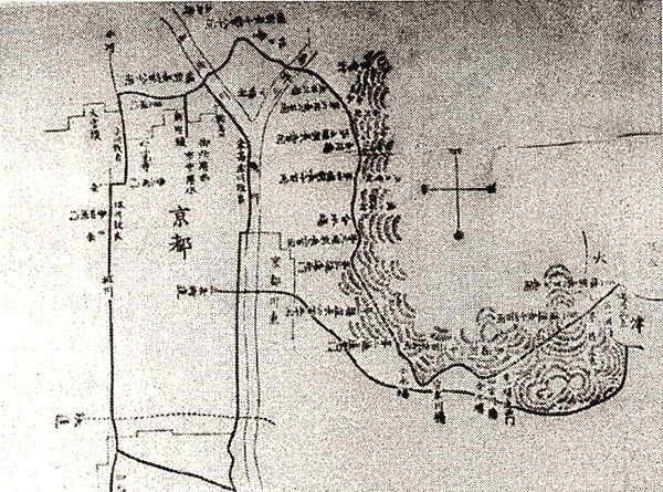
Fig.3 Rout shown in "the conference joined North-South Wards of Kyoto City", 1883.
In the draft put for deliberation, the seven following purposes below were agreed upon.
1. Manufacturing by water power
2. Navigation systems
3. Irrigation water
4. Water rice mill
5. Fire prevention
6. Drinking water
7. City sanitation
The route of this plan had two cannels for shipping as seen in Fig.4. Water mills were arranged at Nyakuouji and Shishigatani district.

Fig.4 November 1883 (Meiji 16).
The conference for encouragement of industry in Kyoto and the conference joined North-South Wards of Kyoto City.
d) in 1884
On May 5th 1884 (Meiji 17), Kyoto prefecture received two plans made by the bureau of construction from Aritomo YAMAGATA, the secretary of the Interior. The first "Kou"plan involved minimal improvement of the Kyoto prefectural plan.14) the points were bricks in tunnels, gutters nearby mountains, and the plan for bridge construction. The second "Otsu"plan was completely originated by the bureau of construction. This plan didn't adopt roundabout cannels. One cannel directly ran through several locks, and the other was mildly roundabout as irrigation water. This irrigation cannel had separate channel for water mills at the Nyakuoji district. (Fig.5)

Fig.5 June 1884 (Meiji 17).
Plan reconstructed by the bureau of construction.
e) After the ground-breaking ceremony
On June 6th in 1885 (Meiji 18), construction of the LBC started from the Otsu area according to the first plan, because there were a few problems nearby Kyoto.
The next year, the plan of the LBC changed in several points, such as the site of the second tunnel, influenced by the second plan originated by the bureau of construction. In 1887 (Meiji 20), the route in Kyoto completely changed and cannels were divided at Keage, the west end of the third tunnel. The main channel for shipping named the Outo Canal ran down to the Okazaki area, and a sub-channel for irrigation ran beside the Higashiyama Mountains. The main channel had an incline system, the first in Japan, in place of locks as in the second plan of the bureau of construction. The width of the Outo Canal was 10-ken (about 18.2 meters) (Fig.6). Incline system was adopted by Dr. TANABE after their visit of U.S.A because of waterpower generation.

Fig.6 April 1890 (Meiji 23).
Completion of the LBC.
In 1888 (Meiji 23), the Kyoto council decided to adopt waterpower generation in the LBC after Dr. TANABE's presentation, and waterpower plants were planned beside incline system.15)
On April 9th in 1890 (Meiji 23), the completion ceremony of the LBC was held at Nakano-shima Island in Ebisu Port. The last section was the Outo Canal, and when this section was constructed all canals between Lake Biwa to Kyoto were filled with water.
(2) Urban development influenced by the LBC
Next, I investigate urban development in Kyoto in relation to the navigation systems of the LBC, in cases of a) along the sub-channel of the LBC, b) in Okazaki district, and c) in Yamashina district.
a) Along the sub-channel of the LBC
At first, the most important problem in planning the LBC was the moderation of the grade by a roundabout route, as Mr. KITAGAKI suggested.
In the early times, an emphasis was placed on maintaining a moderate grade for the sake of providing irrigation water as well as for providing a waterway for transportation. In the conference the North and South Wards joined, the grade between Lake Biwa and Kyoto was 1/865, smaller than 1/423, the data in Mr. MINAMI's report.
However the plan changed in 1884 (Meiji 17) because of the adoption of locks, as suggested in the plan of the bureau of construction. The route was divided into a main channel for shipping and a sub-channel for irrigation and water mills. After 1889 (Meiji 22), the adoption of waterpower generation superseded the need for water mills, and the function of the sub-channel focused strictly on irrigation.
As a result, the sub-channel of the LBC became human-scale stream and environment, different from other channels of the LBC. The water was
supplied to farmlands for irrigation water, filtration plant for service water, and the gardens in houses and temples beside Mt. Higashiyama for the appreciation of water and fire prevention. For example, the promenade of the "Tetsugaku-no-michi", sub-channel of the LBC had enhanced the quality of life in the neighborhood, since the waterway was no longer used for shipping or for providing waterpower etc.
b) Okazaki district
The plan proposed by the bureau of construction attempted to reduce the travel time for shipping by adopting technology such as locks. When incline systems were adopted in 1887 (Meiji 20), the Outo Canal was planned to run straight west from the end of the incline (Fig.7).

Fig. 7 Transition of Outo Canal's route.
But this route involved the necessity of constructing two locks in order to reduce the grade. Thus, the route of the Outo Canal, 10-ken (approximately 18 meters) wide, didn't contain two corners as it dose in its current form. An alternative plan, which took the straightest shortest slant route was presented by Noriyoshi SAKAMAOTO, the manager of the LBC on February 2nd 1888 (Meiji 21). Mr. KITAGAKI said in the conference "In the future, we think Okazaki district will experience urban development. And the slant route didn't suit the master plan of city (because to created a triangle site)" and thus rejected the slant route.
Therefore Outo Canal, which was designed for shipping in an urban area, produced a rich waterfront, as Dr. TANABE said that "Especially, Kyoto didn't have a large water surface. So, if the Outo Canal had a 20-ken (about 36 meters) channel, it would become rich place for citizens." The Outo Canal was used for boating and played an active part in the fourth exposition of domestic industry in 1895 (Meiji 28). The most important aspect of the Outo Canal was its large and rich water surface between Ebisugawa and Nanzen-ji, supported by navigation systems.
c) Yamashina district
The LBC played an important part in the urban development of Kyoto city, but didn't influence the Yamashina district, the suburbs of Kyoto. Because the LBC had to pass by the Hinooka peaks, the route ran a high elevation near the northern mountains in the Yamashina district. The LBC had four ports, Hinooka, Takano, Moroha and Shinomiya, but all were located almost in the mountains, and didn't work so much.
Now, people can enjoy the open space along the LBC because of its characters for navigation systems. The promenade was a road for people moving boats, and parks were ports. The LBC produces amenities for Kyoto's citizens changing form.
4. Conclusion
(1) Problems before the plan of the LBC
In the second section, I investigated the plans to supply water from Lake Biwa to Kyoto, which were made before the planning of the LBC. The most serious technical problems were a) grade, and b) connection to other rivers. In those days, engineers had to solve these problems in order to make the LBC into a navigation system.
(2) Influence by shipping
In the third section, I investigated the plan of the LBC. The needs for its use as a navigation system strongly influenced the route and the scenery surrounding the LBC. The need for shipping was expressed in a) a continuous water surface (open space), b) a moderate grade, and c) approaching to the waters easily.
(3) Change of the main purpose of the LBC
From analysis of the LBC's route, I explained the change of the main purpose of the LBC. In early times, navigation systems had to fulfill functions beyond providing irrigation water or waterpower. But the introduction of lock systems and waterpower generation no longer allowed the channels to be continuous. It was possible for a navigation system to fill multiple purposes, showing that transportation was no longer its first role. Waterpower generation would affect the channels of the LBC and Kyoto city dramatically.
References
- Sakuro TANABE, Plans and Diagrams of the Lake Biwa Canal, (1891).
- The Council of Kyoto, Summary of the Lake Biwa Canal, (1895).
- The Council of Kyoto, Summary of the Lake Biwa Cana (2nd edition), (1896).
- Sakuro TANABE, Summary of the Lake Biwa Canal, Maruzen publishing, (1920).
- Kyoto City, "The history of flood in Kyoto", (1936-).
- produced by the bureau of Electric Kyoto City, The enterprises using waterpower of the Lake Biwa Canal, (1940).
- Kyoto Prefecture, The chronological table of Kyoto prefecture 7 - the part of Construction / Transportation / Information - , (1970).
- produced by the bureau of Water Kyoto City and the Kyoto Newspaper, 100 years of the Lake Biwa Canal, (1990).
- book No. 6), pp.8-9
- book No. 3), pp.282-283
- book No. 6), pp.883-898
- book No. 3), p.5
- book No. 3), pp.15-16
- book No. 8), p.89
- book No. 6), pp.188-191
|